Archive
Searching (again!?) for the SS Central America
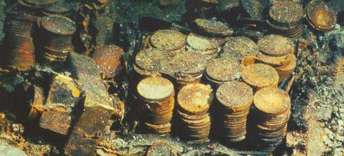
On Tuesday, September 8th 1857, the steamboat SS Central America left Havana at 9 AM for New York, carrying about 600 passengers and crew members. Inside of this vessel, there was stowed a very precious cargo: a set of manuscripts by John James Audubon, and three tons of gold bars and coins. The manuscripts documented an expedition through the yet uncharted southwestern United States and California, and contained 200 sketches and paintings of its wildlife. The gold, fruit of many years of prospecting and mining during the California Gold Rush, was meant to start anew the lives of many of the passengers aboard.
On the 9th, the vessel ran into a storm which developed into a hurricane. The steamboat endured four hard days at sea, and by Saturday morning the ship was doomed. The captain arranged to have women and children taken off to the brig Marine, which offered them assistance at about noon. In spite of the efforts of the remaining crew and passengers to save the ship, the inevitable happened at about 8 PM that same day. The wreck claimed the lives of 425 men, and carried the valuable cargo to the bottom of the sea.
It was not until late 1980s that technology allowed recovery of shipwrecks at deep sea. But no technology would be of any help without an accurate location of the site. In the following paragraphs we would like to illustrate the power of the scipy stack by performing a simple simulation, that ultimately creates a dataset of possible locations for the wreck of the SS Central America, and mines the data to attempt to pinpoint the most probable target.
We simulate several possible paths of the steamboat (say 10,000 randomly generated possibilities), between 7:00 AM on Saturday, and 13 hours later, at 8:00 pm on Sunday. At 7:00 AM on that Saturday the ship’s captain, William Herndon, took a celestial fix and verbally relayed the position to the schooner El Dorado. The fix was 31º25′ North, 77º10′ West. Because the ship was not operative at that point—no engine, no sails—, for the next thirteen hours its course was solely subjected to the effect of ocean current and winds. With enough information, it is possible to model the drift and leeway on different possible paths.
Blanco-Silva’s Books
Click on either image for more information


In the news:


 Math updates on arXiv.org
- On the image of the total power operation for Burnside rings
- A note on hidden classes in spinor classification
- Modularity of certain products of the Rogers-Ramanujan continued fraction
- Complex Analytic Structure of Stationary Flows of an Ideal Incompressible Fluid
- Learning the local density of states of a bilayer moir\'e material in one dimension
- Hypergeometric Distribution Revisited: Tail Inequalities, Confidence Bounds and Sample Sizes
- Positive formula for the product of conjugacy classes on the unitary group
- Neural Estimation Of Entropic Optimal Transport
- Some Homological Conjectures Over Idealization Rings
- On kernels of homological representations of mapping class groups
sagemath
- An error has occurred; the feed is probably down. Try again later.
